

How Was the Bosphorus Strait Formed
Which overflowed First, the Mediterranean or the Black Sea?

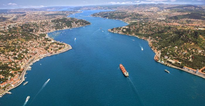
The Bosphorus Strait is the narrow channel of water connecting the Black Sea to the Sea of Marmara and the Mediterranean Sea. The Bosphorus itself runs through the city of Istanbul, Turkey and is only 1 kilometer wide at its narrowest point. Today you can walk along the shore of the Bosphorus and watch dolphins frolicking in the water. While calm and peaceful today, this was the site of the one of the terrible calamities of ancient history.
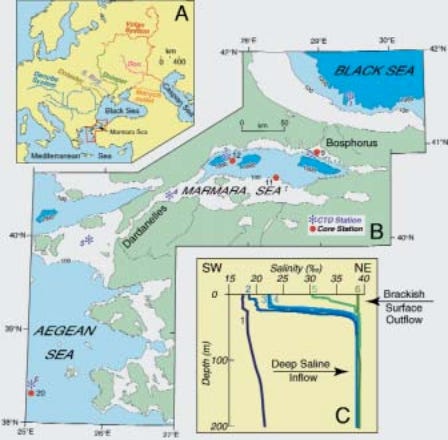
Before attempting to match up the eyewitness accounts that marked the end of the Ice Age with the geological record, we must take an excursus to determine the order and direction of the overflow that created the Bosphorus Strait between the Mediterranean and the Black Sea that should be obvious to geologists, but for some reason is not. The current scholarly consensus is that the Bosphorus was formed when the Mediterranean overflowed into the Black Sea (figure 2), though a minority argue the opposite. The majority position is clearly wrong, as will be argued below.

While the Mediterranean later did overflow in the opposite direction after the channel had already been cut, there are two obvious reasons the Mediterranean could not have been the first to overflow the Bosphorus sill.
The Bosphorus Sill was Too High
First, the ridgeline or sill that had to be overtopped at the Bosphorus has a minimum elevation of 90 meters along its entire 250 kilometer length, with the exception of the Bosphorus channel itself. However, the ridge on either side of the Bosphorus rises to 180 meters. Therefore, prior to the channel being cut by water, the Bosphorus was not even the lowest point along that sill. The reason the flood cut the channel at the Bosphorus was that the North Anatolian Fault (NAF) created a weak point in the sill, making a fissure for water to flow through. The underlying rock is not soluble, therefore the channel was cut purely purely by mechanical erosion of water flowing through the fault.
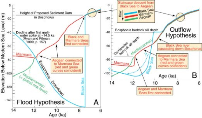
Even if all the ice on the earth today melted and flowed into the world ocean, the highest sea level would be about 70 meters. Therefore, the Mediterranean could never have overflowed the 90-meter ridge north into the Black Sea Basin to cut the Bosphorus channel. While the NAF created a path for the water to flow without necessarily overtopping the 90 meter sill, there still would have to have been a significant head difference between the two bodies of water to generate the flow and velocity required to erode the entire channel to its current width of 1 kilometer and depth of 36 meters below sea level. It is far more likely that the Black Sea, being the smaller basin, was overfilled to create the head difference that generated the force of water that exploited the fault and cut the Bosphorus channel.
The Gibraltar sill that is believed to have existed prior to the Zanclean Flood was less than 10 meters above sea level. Therefore, even if the Mediterranean had a massive continental source of water higher than its rate of evaporation, it would have overflowed outward into the Atlantic at Gibraltar, or at Suez of similar elevation, without ever reaching the necessary height to cut the Bosphorus.
During Deglaciation, the Smallest Basins Overflowed First
Second, the combined Black-Caspian Sea basin drained the southeastern side of the Scandinavian Ice Sheet, which is estimated to have contained 15% of the “extra ice” at the last glacial maximum. According to geologists, after the last glacial maximum, as the Scandinavian Ice Sheet melted it created the Baltic Ice Lake, blocked by a glacial dam, which kept the water level at 150 meters above sea level. Around the era of the Younger Dryas the ice dam was finally breached and the entire Baltic Ice Lake drained into the North Atlantic. However, prior to the dam breach, during the GM and deglaciation, meltwater from the Scandinavian Ice Sheet overtopped the divide and flowed south into the Black-Caspian drainage. The elevation of the divide between the basins was so low that only a modest rise in water level behind the ice dam was needed to redirect flow southward.
While the combined watershed of the Black and Caspian Seas is quite large, it is miniscule in both area and volume compared to the world ocean. At the glacial maximum, the world ocean is estimated to have been 135 meters lower, the Mediterranean 1,000 meters lower, and the Black Sea somewhere between 30 and 100 meters lower. The top 100 m of the Black Sea holds about 43,640 km³ of water, while the top 135 m of the world ocean holds approximately 48,856,500 km³ — roughly 1,120 times more. Put another way, the Black Sea’s top 100 m represents only about 0.089% of the world ocean’s top 135-meter layer.
As the glaciers began melting, their waters flowed to the world ocean, the Black-Caspian Sea basin, and the closed Mediterranean Basin depending on the watershed. The Mediterranean had the least proportional exposure to glacial meltwaters of the three, while the Black-Caspian basin had the highest relative exposure to meltwater. All other things being equal (such as the relative inflow of meltwater), the smallest basin by volume would naturally have overflowed first. Being the smallest by area and having the greatest exposure to glacial meltwater relative to its volume, the Black Sea basin logically had to overflow long before the Atlantic or Mediterranean could have done so.
Eyewitnesses Saw the Flood that Carved the Bosphorus Strait
Finally, we have the eyewitness testimony to the event, by the people who saw it, recorded by Diodorus Siculus:
[5.47.3] … And the Samothracians have a story that, before the floods which befell other peoples, a great one took place among them, in the course of which the outlet at the Cyanean Rocks was first rent asunder and then the Hellespont.
[5.47.4] For the Pontus [the Black Sea], which had at the time the form of a lake, was so swollen by the rivers which flow into it, that, because of the great flood which had poured into it, its waters burst forth violently into the Hellespont and flooded a large part of the coast of Asia and made no small amount of the level part of the island of Samothrace into a sea; and this is the reason, we are told, why in later times fishermen have now and then brought up in their nets the stone capitals of columns, since even cities were covered by the inundation.”
[5.47.5] The inhabitants who had been caught by the flood, the account continues, ran up to the higher regions of the island; and when the sea kept rising higher and higher, they prayed to the native gods,”
– (Diodorus 1935, V.47.3-5)
The eyewitness testimony from history agrees with our logic that the Bosphorus was formed by the overflowing of the Black Sea within recorded history. Disregarding the evolutionary narrative of many cyclical ice ages in favor of the creationist hypothesis of a single Ice Age, we might conclude that the initial breach of the Bosphorus was caused by an overflow from the Black Sea, which preceded the overflow and breach of Gibraltar by the rising Atlantic. Both events occurred during the deglaciation of the Ice Age, but were separated by several decades.
As we have argued in the paper CFAH-19 (unpublished at this writing), the Flood of Deucalion in which the Black Sea overflowed occurred in 1491 BC, and was the direct result of the Fire of Phaeton melting a substantial portion of the Scandanavian Ice Sheet. The Bosphorus Strait was created as a consequence of one of the chain of catastrophic events surrounding the Exodus of Israel from Egypt in 1491 BC.
This kind of blindness is typical of old-earthers. There are ancient accounts of how it happened, but because today's secular experts are so sure it happened 9,400 years ago, they ignore the stories as coincidentally similar myths.
Interesting.
I second everything Ryan said in his comment. Sometimes ignorance is a choice…